Paper · 2026
Leaving the City: A Large-Scale Aerial Dataset for Cross-Season Localization in Unstructured Environments
ECCV 2026(Poster)
Leaving the City (LTC) is a large-scale aerial dataset for cross-season localization in unstructured environments.
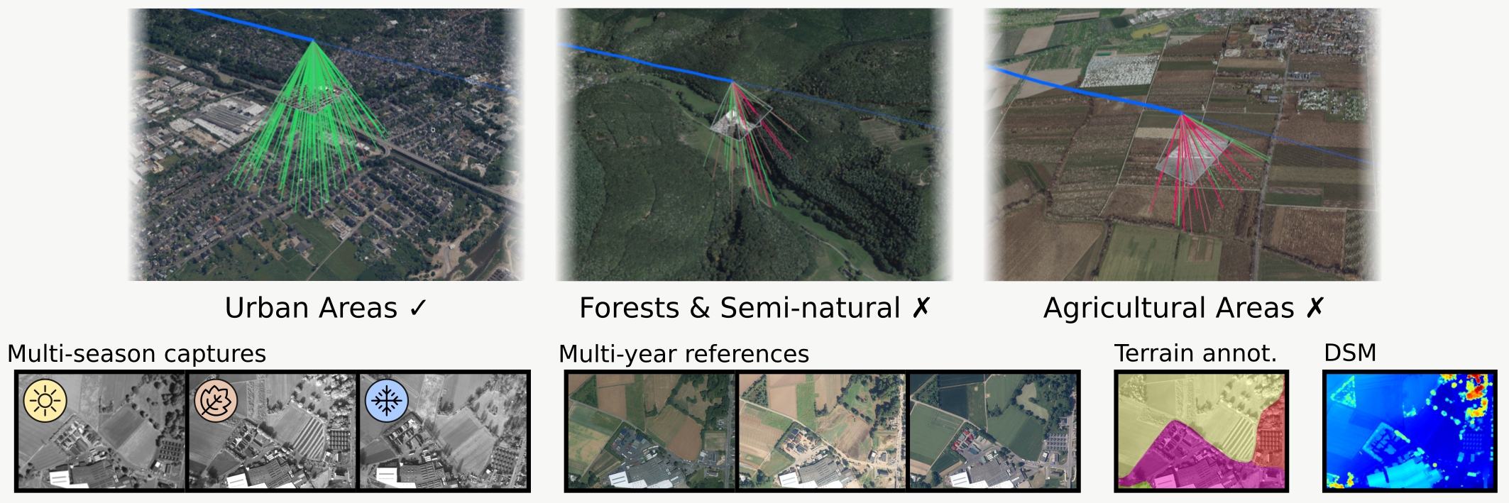
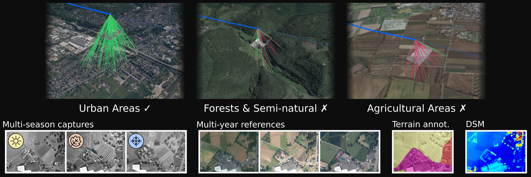
LTC provides aerial recordings captured across multiple seasons and environmental conditions, targeting robust localization beyond structured urban scenes. The dataset focuses on challenging unstructured environments such as forests, fields, rural areas, and repetitive natural landscapes, where visual localization is particularly difficult.
The dataset includes multiple flight sequences together with calibration data, sensor metadata, aerial imagery, semantic coverage information, and land-cover annotations.
Video overview
Preparing local video preview…
Dataset at a glance
Repeated aerial recordings across western Germany capture long-term appearance change at a scale that supports both aggregate and terrain-aware evaluation.
- 1,379 km
- Flight trajectories
- Across repeatedly flown routes
- 1.65 M
- Aerial images
- Global-shutter grayscale imagery
- 3
- Seasons
- Winter · summer · autumn
- 6
- Flight campaigns
- February 2022 – January 2024
- 2 routesapproximately 125 km and 335 km
- 9 h 48 mintotal recorded flight time
- 4 terrain classesartificial surfaces, agricultural areas, forest and semi-natural areas, wetlands and waterbodies
- 50 / 200 Hzcamera / inertial data and 6-DoF ground truth
Explore the flight routes
The two repeatedly flown routes can be inspected together or individually. Select one of the numbered points and switch between the available flight campaigns to compare the nearest recorded camera frames across seasons.
Loading interactive map…
Satellite background: Sentinel2-DE RGB (2019) — European Union, contains Copernicus Sentinel-2 data 2019, processed by the Bundesamt für Kartographie und Geodäsie (BKG). Land-cover background: CORINE Land Cover – 5ha (2018), © GeoBasis-DE / BKG (2026), dl-de/by-2-0.
Abstract
Long-term aerial localization requires matching live flight imagery against archival reference maps, demanding feature representations that are invariant to severe appearance changes and perceptual aliasing. However, current benchmarks report only aggregate accuracy over predominantly man-made environments, masking severe terrain-dependent performance gaps. As a result, localization performance over unstructured natural landscapes — where self-similar textures and drastic seasonal changes dominate — remains effectively unmeasured.
To address this, we introduce Leaving the City, the first large-scale aerial benchmark designed to isolate and quantify terrain-dependent localization gaps. Captured via a microlight aircraft, our dataset comprises 1,379 km of flight trajectories flown repeatedly to capture distinct seasonal variations. We pair high-frame-rate imagery and inertial measurements with semantic terrain masks, multi-year-old orthophotos, and precise 6-DoF ground truth.
Evaluating state-of-the-art matchers through our terrain-stratified protocol reveals a systematic bias: methods that succeed on man-made surfaces degrade sharply over natural terrain undergoing strong appearance change. By exposing where current methods fail, our benchmark provides a rigorous foundation for developing robust, all-terrain aerial localization. The dataset and code are publicly available.
Terrain-aware matching
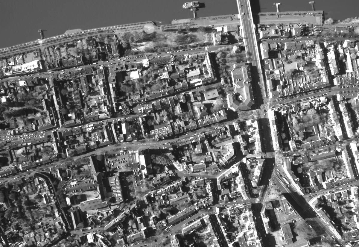
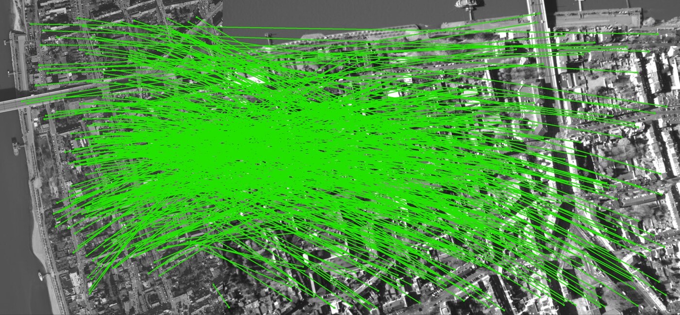
The same matcher can behave very differently depending on the terrain beneath the aircraft. Select a terrain class, then drag across the query image to compare the recorded appearance with its land-cover annotation. The correspondence view below shows the geometrically verified matches between the archival orthoreference and the aerial query.
 Land cover
Aerial image
Land cover
Aerial image

Dataset Download
The dataset is organized into the following flight campaigns:
2022-02-23-11-45-352022-02-23-15-53-202022-06-10-10-42-222022-06-14-10-16-482022-10-19-14-14-592024-01-29-12-31-01
In addition, global metadata are provided under a shared meta folder.
The expected local dataset layout is documented in the DATA README.
The dataset can be browsed directly via directory access at ltc.cvg.cit.tum.de.
Individual download links are provided at the bottom of this page.
For questions, download problems, or issues with the dataset, please open an issue in the Pygeon repository.
License
The LTC dataset is licensed under the Creative Commons Attribution 4.0 International License (CC BY 4.0), © 2026 Fraunhofer-Gesellschaft zur Förderung der angewandten Forschung e.V., represented by Fraunhofer FKIE (see LICENSE.txt). You may share and adapt the data for any purpose, including commercially, provided that you cite the paper and indicate if changes were made. The land-cover masks are derived from CORINE Land Cover 5 ha, 2018 (CLC5-2018): © GeoBasis-DE / BKG (2025), dl-de/by-2-0; modified: rasterized into masks aligned with the camera images. The code in pygeon is released under the MIT License.
Download the complete dataset
wget --mirror --no-parent --no-host-directories \
  --reject-regex='[?]C=' \
  --reject='index.html*' \
  --directory-prefix=ltc-dataset \
  https://ltc.cvg.cit.tum.de/
Download a single campaign
Replace the <campaign> in the command below with one of the campaign identifiers listed above:
wget --mirror --no-parent --no-host-directories \
  --reject-regex='[?]C=' \
  --reject='index.html*' \
  --cut-dirs=1 \
  --directory-prefix=<campaign> \
  https://ltc.cvg.cit.tum.de/<campaign>/
For example, to download the campaign 2022-06-14-10-16-48:
wget --mirror --no-parent --no-host-directories \
  --reject-regex='[?]C=' \
  --reject='index.html*' \
  --cut-dirs=1 \
  --directory-prefix=2022-06-14-10-16-48 \
  https://ltc.cvg.cit.tum.de/2022-06-14-10-16-48/
Download global metadata
wget --mirror --no-parent --no-host-directories \
  --reject-regex='[?]C=' \
  --reject='index.html*' \
  --cut-dirs=1 \
  --directory-prefix=meta \
  https://ltc.cvg.cit.tum.de/meta/
Sequence Downloads
2022-02-23-11-45-35 — 31 files, 187.6 GiB
Calibration
- calibration/camera.json (296 B)
- calibration/extrinsics.json (686 B)
- calibration/imu_noise.json (222 B)
Image archives
- images/2022-02-23-11-45-35_images_00000.zip (10.9 GiB)
- images/2022-02-23-11-45-35_images_00001.zip (11.2 GiB)
- images/2022-02-23-11-45-35_images_00002.zip (10.8 GiB)
- images/2022-02-23-11-45-35_images_00003.zip (9.9 GiB)
- images/2022-02-23-11-45-35_images_00004.zip (11.1 GiB)
- images/2022-02-23-11-45-35_images_00005.zip (11.1 GiB)
- images/2022-02-23-11-45-35_images_00006.zip (10.8 GiB)
- images/2022-02-23-11-45-35_images_00007.zip (11.3 GiB)
- images/2022-02-23-11-45-35_images_00008.zip (11.4 GiB)
- images/2022-02-23-11-45-35_images_00009.zip (11.3 GiB)
- images/2022-02-23-11-45-35_images_00010.zip (11.1 GiB)
- images/2022-02-23-11-45-35_images_00011.zip (10.8 GiB)
- images/2022-02-23-11-45-35_images_00012.zip (10.8 GiB)
- images/2022-02-23-11-45-35_images_00013.zip (9.9 GiB)
- images/2022-02-23-11-45-35_images_00014.zip (9.6 GiB)
- images/2022-02-23-11-45-35_images_00015.zip (10.8 GiB)
- images/2022-02-23-11-45-35_images_00016.zip (10.5 GiB)
- images/2022-02-23-11-45-35_images_00017.zip (2.6 GiB)
Land-cover annotations
Metadata
- meta/image_bounding_boxes.csv (12.3 MiB)
- meta/semantic_coverage.csv (14.7 MiB)
Core sensor files
- barometer.csv (9.0 MiB)
- camera.csv (4.8 MiB)
- gps_hdt.csv (1.8 MiB)
- gps_pos_vel.csv (5.9 MiB)
- imu.csv (265.4 MiB)
- ins.csv (276.9 MiB)
- magnetometer.csv (30.3 MiB)
2022-02-23-15-53-20 — 31 files, 178.8 GiB
Calibration
- calibration/camera.json (297 B)
- calibration/extrinsics.json (678 B)
- calibration/imu_noise.json (222 B)
Image archives
- images/2022-02-23-15-53-20_images_00000.zip (10.4 GiB)
- images/2022-02-23-15-53-20_images_00001.zip (10.9 GiB)
- images/2022-02-23-15-53-20_images_00002.zip (9.5 GiB)
- images/2022-02-23-15-53-20_images_00003.zip (9.9 GiB)
- images/2022-02-23-15-53-20_images_00004.zip (9.3 GiB)
- images/2022-02-23-15-53-20_images_00005.zip (10.3 GiB)
- images/2022-02-23-15-53-20_images_00006.zip (10.3 GiB)
- images/2022-02-23-15-53-20_images_00007.zip (9.8 GiB)
- images/2022-02-23-15-53-20_images_00008.zip (10.3 GiB)
- images/2022-02-23-15-53-20_images_00009.zip (11.3 GiB)
- images/2022-02-23-15-53-20_images_00010.zip (11.3 GiB)
- images/2022-02-23-15-53-20_images_00011.zip (10.8 GiB)
- images/2022-02-23-15-53-20_images_00012.zip (10.7 GiB)
- images/2022-02-23-15-53-20_images_00013.zip (9.7 GiB)
- images/2022-02-23-15-53-20_images_00014.zip (9.5 GiB)
- images/2022-02-23-15-53-20_images_00015.zip (10.4 GiB)
- images/2022-02-23-15-53-20_images_00016.zip (10.0 GiB)
- images/2022-02-23-15-53-20_images_00017.zip (2.8 GiB)
Land-cover annotations
Metadata
- meta/image_bounding_boxes.csv (12.1 MiB)
- meta/semantic_coverage.csv (14.6 MiB)
Core sensor files
- barometer.csv (9.0 MiB)
- camera.csv (4.9 MiB)
- gps_hdt.csv (1.8 MiB)
- gps_pos_vel.csv (5.8 MiB)
- imu.csv (265.2 MiB)
- ins.csv (276.5 MiB)
- magnetometer.csv (30.4 MiB)
2022-06-10-10-42-22 — 28 files, 155.4 GiB
Calibration
- calibration/camera.json (297 B)
- calibration/extrinsics.json (684 B)
- calibration/imu_noise.json (222 B)
Image archives
- images/2022-06-10-10-42-22_images_00000.zip (10.0 GiB)
- images/2022-06-10-10-42-22_images_00001.zip (10.5 GiB)
- images/2022-06-10-10-42-22_images_00002.zip (10.2 GiB)
- images/2022-06-10-10-42-22_images_00003.zip (10.9 GiB)
- images/2022-06-10-10-42-22_images_00004.zip (11.2 GiB)
- images/2022-06-10-10-42-22_images_00005.zip (10.9 GiB)
- images/2022-06-10-10-42-22_images_00006.zip (10.5 GiB)
- images/2022-06-10-10-42-22_images_00007.zip (10.9 GiB)
- images/2022-06-10-10-42-22_images_00008.zip (11.2 GiB)
- images/2022-06-10-10-42-22_images_00009.zip (10.7 GiB)
- images/2022-06-10-10-42-22_images_00010.zip (11.1 GiB)
- images/2022-06-10-10-42-22_images_00011.zip (10.0 GiB)
- images/2022-06-10-10-42-22_images_00012.zip (10.1 GiB)
- images/2022-06-10-10-42-22_images_00013.zip (10.4 GiB)
- images/2022-06-10-10-42-22_images_00014.zip (5.1 GiB)
Land-cover annotations
Metadata
- meta/image_bounding_boxes.csv (9.9 MiB)
- meta/semantic_coverage.csv (12.1 MiB)
Core sensor files
- barometer.csv (7.7 MiB)
- camera.csv (4.1 MiB)
- gps_hdt.csv (1.5 MiB)
- gps_pos_vel.csv (4.9 MiB)
- imu.csv (224.0 MiB)
- ins.csv (233.9 MiB)
- magnetometer.csv (25.7 MiB)
2022-06-14-10-16-48 — 52 files, 432.9 GiB
Calibration
- calibration/camera.json (297 B)
- calibration/extrinsics.json (688 B)
- calibration/imu_noise.json (222 B)
Image archives
- images/2022-06-14-10-16-48_images_00000.zip (10.2 GiB)
- images/2022-06-14-10-16-48_images_00001.zip (11.6 GiB)
- images/2022-06-14-10-16-48_images_00002.zip (10.8 GiB)
- images/2022-06-14-10-16-48_images_00003.zip (11.9 GiB)
- images/2022-06-14-10-16-48_images_00004.zip (11.5 GiB)
- images/2022-06-14-10-16-48_images_00005.zip (10.7 GiB)
- images/2022-06-14-10-16-48_images_00006.zip (10.8 GiB)
- images/2022-06-14-10-16-48_images_00007.zip (11.1 GiB)
- images/2022-06-14-10-16-48_images_00008.zip (10.4 GiB)
- images/2022-06-14-10-16-48_images_00009.zip (11.0 GiB)
- images/2022-06-14-10-16-48_images_00010.zip (10.4 GiB)
- images/2022-06-14-10-16-48_images_00011.zip (11.6 GiB)
- images/2022-06-14-10-16-48_images_00012.zip (11.5 GiB)
- images/2022-06-14-10-16-48_images_00013.zip (11.0 GiB)
- images/2022-06-14-10-16-48_images_00014.zip (11.0 GiB)
- images/2022-06-14-10-16-48_images_00015.zip (10.3 GiB)
- images/2022-06-14-10-16-48_images_00016.zip (11.2 GiB)
- images/2022-06-14-10-16-48_images_00017.zip (11.7 GiB)
- images/2022-06-14-10-16-48_images_00018.zip (10.5 GiB)
- images/2022-06-14-10-16-48_images_00019.zip (11.6 GiB)
- images/2022-06-14-10-16-48_images_00020.zip (11.0 GiB)
- images/2022-06-14-10-16-48_images_00021.zip (11.2 GiB)
- images/2022-06-14-10-16-48_images_00022.zip (11.4 GiB)
- images/2022-06-14-10-16-48_images_00023.zip (12.0 GiB)
- images/2022-06-14-10-16-48_images_00024.zip (11.8 GiB)
- images/2022-06-14-10-16-48_images_00025.zip (12.0 GiB)
- images/2022-06-14-10-16-48_images_00026.zip (11.6 GiB)
- images/2022-06-14-10-16-48_images_00027.zip (11.8 GiB)
- images/2022-06-14-10-16-48_images_00028.zip (11.4 GiB)
- images/2022-06-14-10-16-48_images_00029.zip (11.2 GiB)
- images/2022-06-14-10-16-48_images_00030.zip (10.6 GiB)
- images/2022-06-14-10-16-48_images_00031.zip (11.0 GiB)
- images/2022-06-14-10-16-48_images_00032.zip (11.4 GiB)
- images/2022-06-14-10-16-48_images_00033.zip (11.3 GiB)
- images/2022-06-14-10-16-48_images_00034.zip (11.2 GiB)
- images/2022-06-14-10-16-48_images_00035.zip (10.5 GiB)
- images/2022-06-14-10-16-48_images_00036.zip (10.8 GiB)
- images/2022-06-14-10-16-48_images_00037.zip (10.3 GiB)
- images/2022-06-14-10-16-48_images_00038.zip (4.6 GiB)
Land-cover annotations
Metadata
- meta/image_bounding_boxes.csv (28.9 MiB)
- meta/semantic_coverage.csv (35.8 MiB)
Core sensor files
- barometer.csv (20.4 MiB)
- camera.csv (10.6 MiB)
- gps_hdt.csv (4.0 MiB)
- gps_pos_vel.csv (13.0 MiB)
- imu.csv (589.5 MiB)
- ins.csv (615.6 MiB)
- magnetometer.csv (67.5 MiB)
2022-10-19-14-14-59 — 57 files, 492.5 GiB
Calibration
- calibration/camera.json (296 B)
- calibration/extrinsics.json (693 B)
- calibration/imu_noise.json (222 B)
Image archives
- images/2022-10-19-14-14-59_images_00000.zip (10.1 GiB)
- images/2022-10-19-14-14-59_images_00001.zip (11.6 GiB)
- images/2022-10-19-14-14-59_images_00002.zip (10.6 GiB)
- images/2022-10-19-14-14-59_images_00003.zip (11.6 GiB)
- images/2022-10-19-14-14-59_images_00004.zip (11.5 GiB)
- images/2022-10-19-14-14-59_images_00005.zip (10.9 GiB)
- images/2022-10-19-14-14-59_images_00006.zip (11.0 GiB)
- images/2022-10-19-14-14-59_images_00007.zip (11.0 GiB)
- images/2022-10-19-14-14-59_images_00008.zip (10.8 GiB)
- images/2022-10-19-14-14-59_images_00009.zip (11.1 GiB)
- images/2022-10-19-14-14-59_images_00010.zip (11.1 GiB)
- images/2022-10-19-14-14-59_images_00011.zip (10.5 GiB)
- images/2022-10-19-14-14-59_images_00012.zip (11.6 GiB)
- images/2022-10-19-14-14-59_images_00013.zip (11.4 GiB)
- images/2022-10-19-14-14-59_images_00014.zip (11.3 GiB)
- images/2022-10-19-14-14-59_images_00015.zip (10.9 GiB)
- images/2022-10-19-14-14-59_images_00016.zip (11.0 GiB)
- images/2022-10-19-14-14-59_images_00017.zip (10.9 GiB)
- images/2022-10-19-14-14-59_images_00018.zip (11.4 GiB)
- images/2022-10-19-14-14-59_images_00019.zip (11.7 GiB)
- images/2022-10-19-14-14-59_images_00020.zip (11.1 GiB)
- images/2022-10-19-14-14-59_images_00021.zip (12.1 GiB)
- images/2022-10-19-14-14-59_images_00022.zip (12.6 GiB)
- images/2022-10-19-14-14-59_images_00023.zip (11.6 GiB)
- images/2022-10-19-14-14-59_images_00024.zip (11.3 GiB)
- images/2022-10-19-14-14-59_images_00025.zip (11.8 GiB)
- images/2022-10-19-14-14-59_images_00026.zip (11.8 GiB)
- images/2022-10-19-14-14-59_images_00027.zip (11.6 GiB)
- images/2022-10-19-14-14-59_images_00028.zip (12.1 GiB)
- images/2022-10-19-14-14-59_images_00029.zip (11.4 GiB)
- images/2022-10-19-14-14-59_images_00030.zip (12.1 GiB)
- images/2022-10-19-14-14-59_images_00031.zip (11.3 GiB)
- images/2022-10-19-14-14-59_images_00032.zip (11.7 GiB)
- images/2022-10-19-14-14-59_images_00033.zip (11.3 GiB)
- images/2022-10-19-14-14-59_images_00034.zip (10.5 GiB)
- images/2022-10-19-14-14-59_images_00035.zip (10.9 GiB)
- images/2022-10-19-14-14-59_images_00036.zip (11.3 GiB)
- images/2022-10-19-14-14-59_images_00037.zip (11.2 GiB)
- images/2022-10-19-14-14-59_images_00038.zip (10.9 GiB)
- images/2022-10-19-14-14-59_images_00039.zip (9.8 GiB)
- images/2022-10-19-14-14-59_images_00040.zip (10.8 GiB)
- images/2022-10-19-14-14-59_images_00041.zip (10.5 GiB)
- images/2022-10-19-14-14-59_images_00042.zip (11.0 GiB)
- images/2022-10-19-14-14-59_images_00043.zip (4.4 GiB)
Land-cover annotations
Metadata
- meta/image_bounding_boxes.csv (33.0 MiB)
- meta/semantic_coverage.csv (40.5 MiB)
Core sensor files
- barometer.csv (23.1 MiB)
- camera.csv (12.0 MiB)
- gps_hdt.csv (4.5 MiB)
- gps_pos_vel.csv (14.7 MiB)
- imu.csv (667.9 MiB)
- ins.csv (697.7 MiB)
- magnetometer.csv (76.4 MiB)
2024-01-29-12-31-01 — 59 files, 496.7 GiB
Calibration
- calibration/camera.json (297 B)
- calibration/extrinsics.json (681 B)
- calibration/imu_noise.json (222 B)
Image archives
- images/2024-01-29-12-31-01_images_00000.zip (11.9 GiB)
- images/2024-01-29-12-31-01_images_00001.zip (11.2 GiB)
- images/2024-01-29-12-31-01_images_00002.zip (10.7 GiB)
- images/2024-01-29-12-31-01_images_00003.zip (11.5 GiB)
- images/2024-01-29-12-31-01_images_00004.zip (11.3 GiB)
- images/2024-01-29-12-31-01_images_00005.zip (10.8 GiB)
- images/2024-01-29-12-31-01_images_00006.zip (10.8 GiB)
- images/2024-01-29-12-31-01_images_00007.zip (10.7 GiB)
- images/2024-01-29-12-31-01_images_00008.zip (10.6 GiB)
- images/2024-01-29-12-31-01_images_00009.zip (10.5 GiB)
- images/2024-01-29-12-31-01_images_00010.zip (10.2 GiB)
- images/2024-01-29-12-31-01_images_00011.zip (10.3 GiB)
- images/2024-01-29-12-31-01_images_00012.zip (11.0 GiB)
- images/2024-01-29-12-31-01_images_00013.zip (10.9 GiB)
- images/2024-01-29-12-31-01_images_00014.zip (10.7 GiB)
- images/2024-01-29-12-31-01_images_00015.zip (10.4 GiB)
- images/2024-01-29-12-31-01_images_00016.zip (10.8 GiB)
- images/2024-01-29-12-31-01_images_00017.zip (10.5 GiB)
- images/2024-01-29-12-31-01_images_00018.zip (10.7 GiB)
- images/2024-01-29-12-31-01_images_00019.zip (11.2 GiB)
- images/2024-01-29-12-31-01_images_00020.zip (10.8 GiB)
- images/2024-01-29-12-31-01_images_00021.zip (12.0 GiB)
- images/2024-01-29-12-31-01_images_00022.zip (11.3 GiB)
- images/2024-01-29-12-31-01_images_00023.zip (11.1 GiB)
- images/2024-01-29-12-31-01_images_00024.zip (11.0 GiB)
- images/2024-01-29-12-31-01_images_00025.zip (11.8 GiB)
- images/2024-01-29-12-31-01_images_00026.zip (11.2 GiB)
- images/2024-01-29-12-31-01_images_00027.zip (11.6 GiB)
- images/2024-01-29-12-31-01_images_00028.zip (11.6 GiB)
- images/2024-01-29-12-31-01_images_00029.zip (11.4 GiB)
- images/2024-01-29-12-31-01_images_00030.zip (11.7 GiB)
- images/2024-01-29-12-31-01_images_00031.zip (10.9 GiB)
- images/2024-01-29-12-31-01_images_00032.zip (11.1 GiB)
- images/2024-01-29-12-31-01_images_00033.zip (11.1 GiB)
- images/2024-01-29-12-31-01_images_00034.zip (10.8 GiB)
- images/2024-01-29-12-31-01_images_00035.zip (10.3 GiB)
- images/2024-01-29-12-31-01_images_00036.zip (10.7 GiB)
- images/2024-01-29-12-31-01_images_00037.zip (11.3 GiB)
- images/2024-01-29-12-31-01_images_00038.zip (10.1 GiB)
- images/2024-01-29-12-31-01_images_00039.zip (10.5 GiB)
- images/2024-01-29-12-31-01_images_00040.zip (9.8 GiB)
- images/2024-01-29-12-31-01_images_00041.zip (10.0 GiB)
- images/2024-01-29-12-31-01_images_00042.zip (10.1 GiB)
- images/2024-01-29-12-31-01_images_00043.zip (10.2 GiB)
- images/2024-01-29-12-31-01_images_00044.zip (10.5 GiB)
- images/2024-01-29-12-31-01_images_00045.zip (987.8 MiB)
Land-cover annotations
Metadata
- meta/image_bounding_boxes.csv (34.1 MiB)
- meta/semantic_coverage.csv (42.2 MiB)
Core sensor files
- barometer.csv (23.9 MiB)
- camera.csv (12.4 MiB)
- gps_hdt.csv (4.7 MiB)
- gps_pos_vel.csv (15.3 MiB)
- imu.csv (691.3 MiB)
- ins.csv (722.7 MiB)
- magnetometer.csv (79.1 MiB)
Global metadata — 5 files, <0.1 GiB
Shared metadata files
- available_tiles_nrw.csv (315.2 KiB)
- corine_landcover_superclasses.json (647 B)
- historic_tiles_rlp.json (7.6 MiB)
- tile_acquisition_dates_nrw.csv (6.7 MiB)
- tile_acquisition_dates_rlp.csv (1.6 MiB)
Citation
Michael Schleiss, Henry Hölzemann, Fahmi Rouatbi, Torsten Fiolka, Thomas Pany, Roger Förstner, and Daniel Cremers. “Leaving the City: A Large-Scale Aerial Dataset for Cross-Season Localization in Unstructured Environments.” In Computer Vision – ECCV 2026, pp. 96–113. Springer, 2026.
Show BibTeX
@InProceedings{Schleiss_2026_ECCV,
  author    = {Schleiss, Michael and H\"olzemann, Henry and Rouatbi, Fahmi and Fiolka, Torsten and Pany, Thomas and F\"orstner, Roger and Cremers, Daniel},
  title     = {Leaving the City: A Large-Scale Aerial Dataset for Cross-Season Localization in Unstructured Environments},
  booktitle = {Computer Vision -- ECCV 2026},
  year      = {2026},
  publisher = {Springer},
  pages     = {96--113}
}